From Old Maps to Smart Data: How Technology Is Reinventing Historical Property Research
- Mar 11
- 3 min read
Historical property research has long relied on paper records, aging maps, and hours of manual investigation. Today, digital tools are transforming the process and making complex environmental reviews easier to complete. Modern platforms now support tech-enabled Phase 1 Environmental assessments, making them simple for professionals to access property history faster and with greater accuracy.
The Traditional Approach to Property History
For decades, property research required investigators to visit archives, examine microfilm, and sort through local records. Historical maps, fire insurance plans, and municipal documents were often scattered across different offices and libraries. This process was valuable but time consuming and prone to misinformation.
Researchers also depended heavily on handwritten notes and photocopies collected during field visits. Organizing those materials could take just as long as finding them in the first place. As a result, environmental due diligence often required weeks of work before a clear picture of a property's past emerged.
Why Historical Property Research Matters
Understanding the history of a property is essential when evaluating environmental risk. Past industrial activities, underground storage tanks, or waste disposal practices may have left contamination behind. Identifying these risks early helps buyers, developers, and lenders make informed decisions.
Environmental professionals rely on historical evidence to determine how land has been used over time. Changes in ownership, zoning, and nearby industrial activity can all influence a site's environmental condition. Accurate research ensures that potential issues are discovered before they become costly surprises.
The Role of Environmental Due Diligence
One key step in environmental due diligence is to complete a Phase 1 environmental site assessment. This investigation reviews historical records, aerial imagery, and government databases to identify possible environmental concerns. The goal is to determine whether contamination risks may exist on or near the property.
Traditionally, compiling this information required accessing many separate resources. Investigators needed to manually gather historical maps, aerial photos, property records, and regulatory files. Technology now allows these resources to be analyzed together more efficiently.
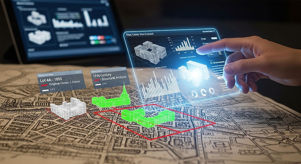
The Digital Transformation of Historical Research
Digital mapping platforms have dramatically changed how property history is analyzed. Large databases now contain scanned historical maps, satellite imagery, and land records from multiple decades. With a few clicks, researchers can compare how a site looked across different periods.
Geographic information systems allow investigators to layer historical data over modern maps. This helps reveal patterns that might otherwise remain hidden in paper archives. It also allows environmental professionals to visualize how land use evolved around a property quickly.
Artificial Intelligence and Smart Data Tools
Artificial intelligence is beginning to play a role in environmental research as well. Machine learning tools can analyze large collections of maps and documents to identify patterns in land use history. These systems can highlight potential red flags, such as former industrial facilities or waste storage areas.
Automated data processing also helps eliminate repetitive manual tasks. Instead of reviewing hundreds of individual documents, professionals can use smart systems that organize and filter relevant information. This allows experts to focus on interpretation rather than on data collection.
Improved Accuracy Through Data Integration
Another major benefit of modern technology is improved data integration. Historical aerial photographs, property boundaries, and environmental records can now be combined into a single system. This unified approach provides a clearer view of potential environmental risks.
Integrated platforms also reduce the chance of missing important information. When multiple data sources are linked together, investigators can easily cross reference details about a property. This creates a more reliable foundation for environmental reporting.
Faster Turnaround for Environmental Reviews
Speed is another major advantage of digital property research. What once required weeks of manual searching can now be completed in a fraction of the time. Professionals can access large historical databases from their offices rather than traveling between archives.
Faster research also benefits clients who need environmental information quickly. Real estate transactions, financing decisions, and development planning often operate on tight timelines. Technology helps ensure that environmental assessments keep pace with those schedules.
The Future of Historical Property Analysis
The future of property research will likely involve even greater automation and data connectivity. More historical records are being digitized each year, expanding the resources available to investigators. This growing pool of data will enable more detailed and comprehensive environmental analysis.
Advanced analytics may also help predict environmental risks before they appear in traditional records. By examining regional patterns and historical land use trends, technology could provide earlier warnings of potential contamination concerns. These insights will strengthen environmental decision making across the industry.
Final Thoughts
Technology is reshaping how environmental professionals explore a property's past. Digital maps, integrated databases, and smart analysis tools have made historical research faster and more reliable. These innovations continue to support tech-enabled Phase 1 Environmental assessments made simple, improving both efficiency and accuracy in environmental due diligence.